Quick Answer
Yes — for most Dacula homeowners, this was a win.
When Gwinnett County planners rejected a 28-unit subdivision on Fence Road (Case RZR2022-00034), they didn’t just block one project. They enforced the rules that protect large-lot character, clean waterways, and the pricing premium that makes Dacula, GA worth owning. Here’s what actually happened — and why it matters to your home’s value.
Picture this: a “For Sale” sign goes up on 14.27 acres along Fence Road in unincorporated Gwinnett County near Dacula. A developer files for a 28-unit subdivision. On paper, the numbers look reasonable — 1.96 units per acre, building heights and setbacks that technically pass inspection. The county’s own checklist shows green checkmarks in most boxes.
And then, unanimously: Denial.
For residents in Dacula’s established neighborhoods — many sitting on homes valued between $423,000 and $500,000 — that single word carries enormous financial weight. In a market where East Gwinnett communities are increasingly competing for buyers who prize space, privacy, and quality of life, the invisible architecture of Gwinnett’s planning code is one of your most powerful — and least appreciated — equity protectors.
What Did Gwinnett County Actually Deny — And Why Does It Matter to You?
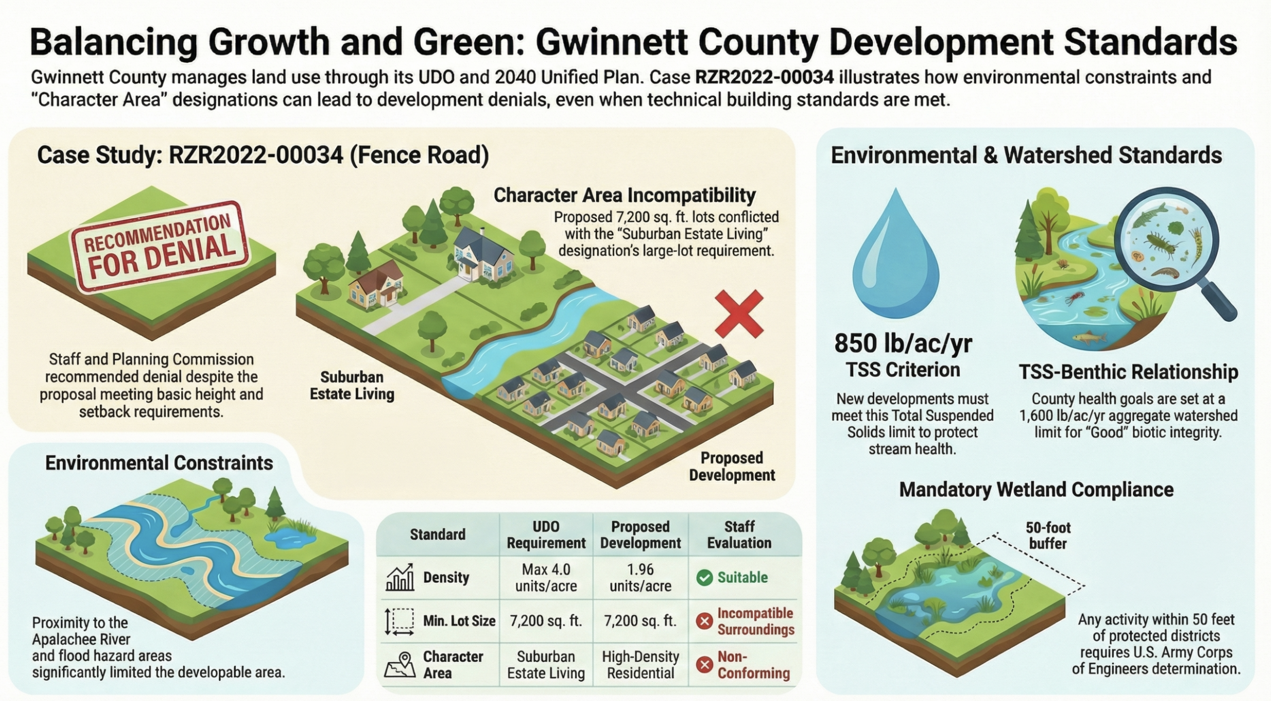
Developer Casgwyn Construction filed Case RZR2022-00034 seeking to rezone a 14.27-acre parcel at 2905 Fence Road from RA-200 (agricultural-residential, requiring roughly five-acre lots) to R-60, which allows 7,200-square-foot lots. The proposal called for 28 detached homes — a net density of 1.96 units per acre.
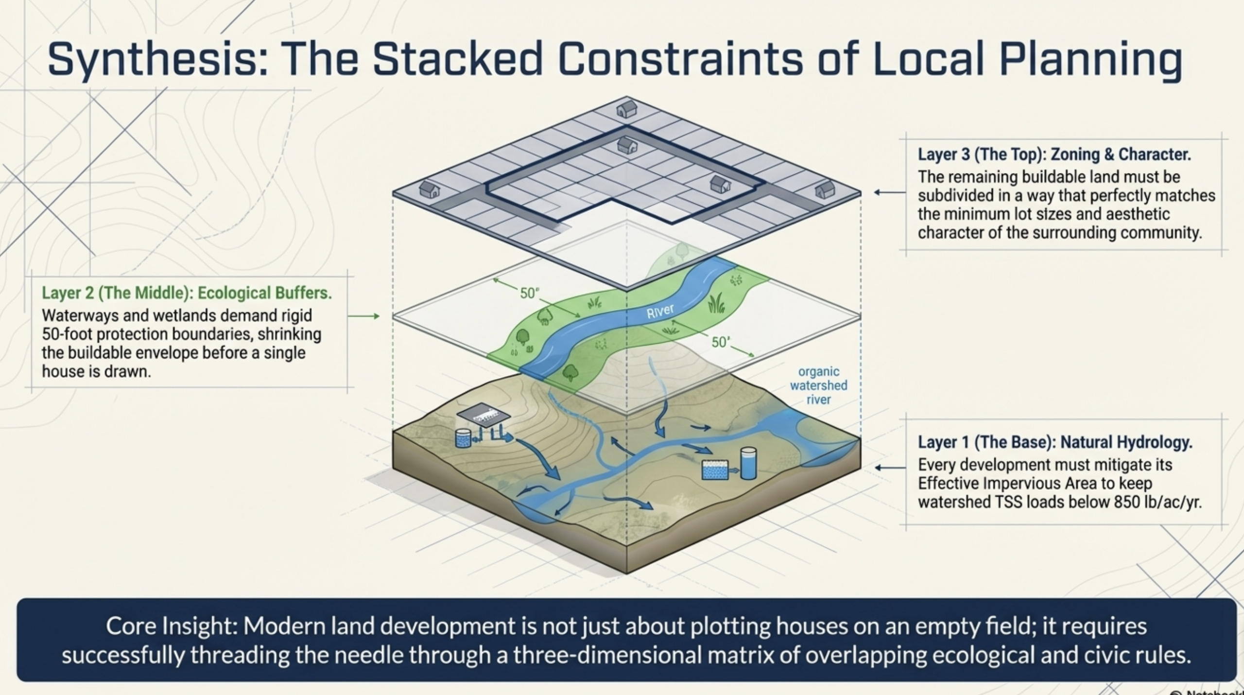
This is not some extreme density request. R-60 subdivisions are common across Gwinnett County. So why the unanimous denial? Because when planners stacked three invisible layers of scrutiny on top of each other, the project collapsed under its own weight.
How Does the “Character Area” Designation Protect Dacula Home Values?
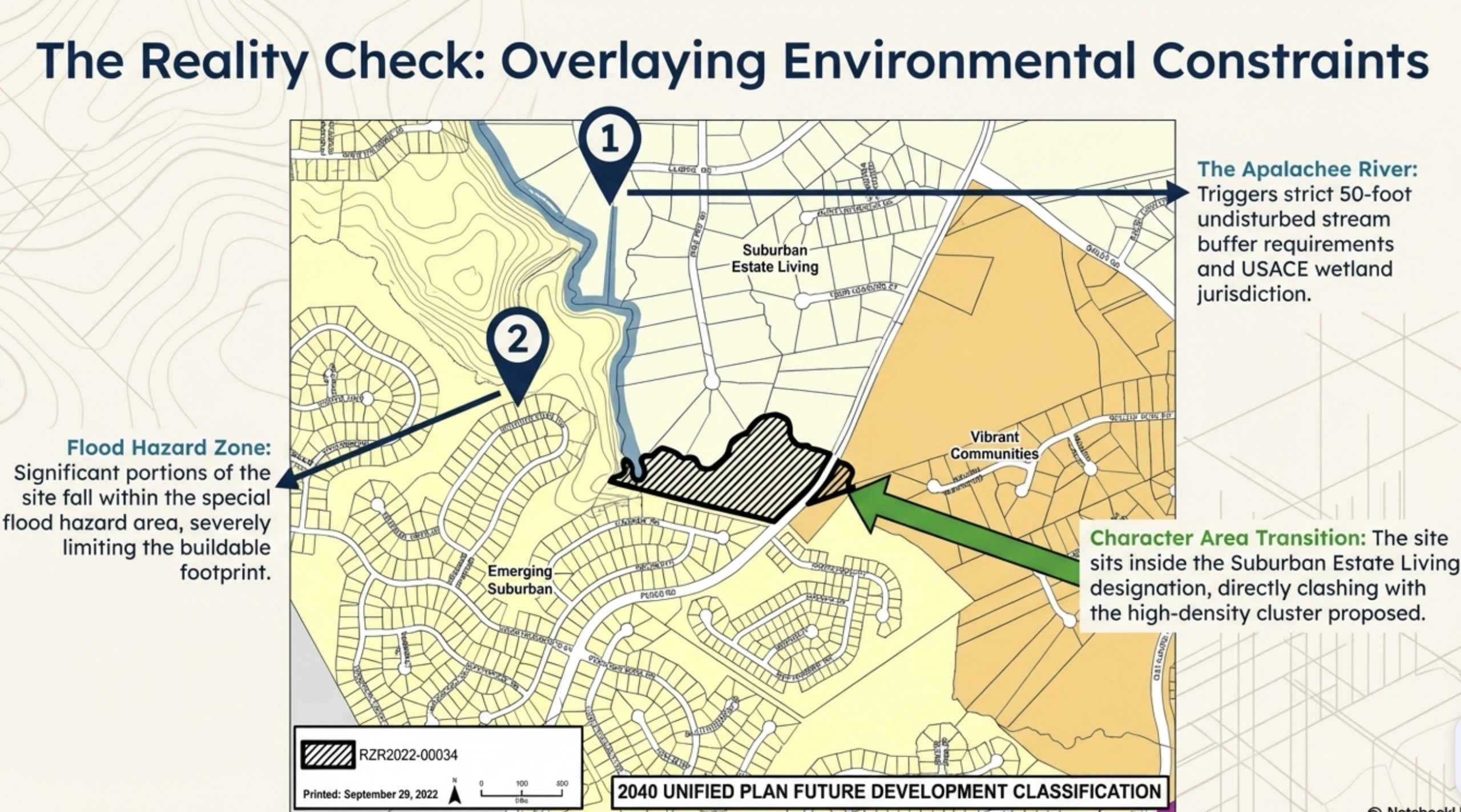
The Fence Road parcel sits within Gwinnett County’s “Suburban Estate Living” character area — a designation in the Gwinnett 2040 Unified Plan that functions as a density ceiling you can’t see on a map but absolutely feel in your appraised value. Named Georgia’s best planning document by the Georgia Planning Association when adopted, the 2040 Unified Plan is the county’s primary tool for directing growth to where it belongs — and keeping it out of where it doesn’t.
The county’s own case report for RZR2022-00034 was explicit: the Suburban Estate Living designation is intended to preserve historical and agricultural character so that new development is low in intensity and consists primarily of large residential lots. A 7,200-square-foot lot subdivision was deemed non-conforming to that vision — period.
For homeowners, this isn’t just bureaucratic language. It’s equity protection in written form. Here’s why:
- Scarcity premium: Estate-sized lots in East Gwinnett are increasingly rare. When zoning guards that scarcity, your home’s lot contributes meaningfully to its overall value.
- Neighborhood cohesion: The adjacent Apalachee Heritage subdivision features lots averaging nearly 10,500 square feet. A 7,200-square-foot cluster next door would have created a visual and market mismatch that drags on neighboring comps.
- Precedent defense: Planners noted their concern about the “density contagion” effect — one approved small-lot subdivision becomes the justification for the next, and the next, until the corridor’s character is gone.
What Role Did the Apalachee River Play in Blocking This Development?
The Apalachee River runs the entire northern property line of 2905 Fence Road. That single geographic fact triggered two simultaneous regulatory walls.
1. The 50-Foot Undisturbed Buffer. Under the Georgia Erosion and Sedimentation Act (O.C.G.A. 12-7), a 50-foot undisturbed riparian buffer is required on each bank of regulated streams. Beyond the state law, the U.S. Army Corps of Engineers holds jurisdiction over any activity affecting wetlands adjacent to navigable waters under Section 404 of the Clean Water Act. Before a single lot could be cleared along the Apalachee, the developer would have needed federal sign-off. The Corps does not rubber-stamp requests near waterways with known wetland features.
2. The Special Flood Hazard Area. Significant portions of the site fall within FEMA’s designated Special Flood Hazard Area — the zone with a 1% annual chance of flooding (the “100-year flood”), where structures carry a 26% chance of flooding over the life of a standard 30-year mortgage. This isn’t an abstract risk — it physically removes buildable area from the site footprint, forcing the developer to cram the same number of units into a much smaller usable envelope, which actually increases the effective density where it matters most.
For Dacula homeowners along or near the Apalachee River corridor, this is directly relevant to your property. A clean, protected river is a lifestyle amenity — and lifestyle amenities are priced into your home’s value every time a buyer tours the neighborhood.
What Is the 850 lb/ac/yr TSS Limit and Why Should Homeowners Care?
If the character area is the “visible” reason for the denial, the watershed science is the technical backstop that makes overriding it nearly impossible.
Gwinnett County’s Watershed Protection Plan — and its codified counterpart in Unified Development Ordinance Section 800-30 — sets a hard limit of 850 pounds of Total Suspended Solids per acre per year for any new development creating 5,000 or more square feet of impervious cover. TSS is the measurement of particulates — sediment, organics, metals — that flow from impervious surfaces into streams. It’s the primary measure of whether a stream can support aquatic life.
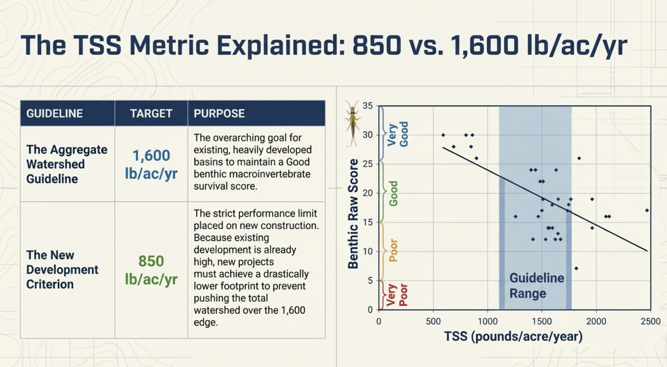
A 14.27-acre site left to uncontrolled development can generate over 1,800 pounds of TSS per acre per year — more than double the allowable limit. The developer would have needed to engineer their way under 850 using Best Management Practices like constructed wetlands, bioretention cells, or sand filters. On a site already constrained by flood zones and river buffers, making that math work — while still delivering 28 profitable lots — was nearly impossible.
The homeowner takeaway: your tax dollars are protected by this standard. Gwinnett’s own watershed planning documents state that retrofitting damaged rivers is 5 to 50 times more expensive than prevention. Every time a high-load project is stopped, Gwinnett avoids a future infrastructure bill measured in millions.
The 50-to-1 Rule
According to Gwinnett County’s watershed planning documents, remediating a degraded stream costs 5 to 50 times more than preventing the damage in the first place. Saying “no” to this subdivision today may have just saved Dacula-area taxpayers millions in future restoration costs — costs that would otherwise flow downstream to your property tax bill.
Is a Zoning Denial Always Good for Existing Homeowners? The Honest Answer.
Let’s be direct here — not every zoning denial is a gift to neighboring homeowners. In some markets, blocking new supply drives prices up for buyers while benefiting sellers. But the nuance matters: what type of supply is being blocked?
This denial isn’t blocking housing supply broadly — the RA-200 zoning still allows the landowner to build a few large, high-value estate homes. What was blocked is a specific type of incompatible density — small lots crammed into a corridor defined by large ones.
For Dacula’s existing homeowners, that distinction is critical. Here’s how the math plays out:
| Scenario | Impact on Existing Home Values | Verdict |
|---|---|---|
| 28 small-lot homes approved next to estate community | Comp suppression; traffic increase; density creep precedent | ❌ |
| Denial issued; RA-200 preserved; estate lots remain rare | Scarcity maintained; character area intact; comps protected | ✅ |
| Apalachee River corridor degraded by overdevelopment | Loss of lifestyle amenity; flood risk increase; future remediation tax burden | ❌ |
The bottom line: if you own a home in Dacula — especially near the Apalachee corridor or in a large-lot neighborhood — Gwinnett County’s planning apparatus just did its job on your behalf.
What Does This Mean If You’re Thinking About Buying or Selling in Dacula?
If you’re a seller: Your home in Dacula’s Suburban Estate Living corridor carries a zoning moat around it. The Gwinnett County Planning & Development Department actively defends these character area designations — as this case proves. When you list, that story matters. Estate-sized lots near the Apalachee with protected character are a real selling point, not marketing fluff. Find out what your home is worth today →
If you’re a buyer: Understanding the zoning landscape before you purchase is critical. Not all of Dacula operates under the same protections — the Emerging Suburban character areas to the south are intentionally designed to absorb density. Knowing which designation governs the land around a home you’re considering could be the difference between a neighborhood that stays as-is and one that changes dramatically over the next ten years. Use the Gwinnett County GIS portal to check the character area for any parcel before you make an offer.
If you’re an investor: Parcels in RA-200 zones along protected corridors have a different risk/reward profile than R-60 infill plays. The upside of large estate lots in Gwinnett is scarcity-driven — which is a legitimate long-term thesis — but you cannot count on density rezones as your exit. This case is exactly why.
The Bigger Picture: What Keeps Gwinnett’s Remaining Green Corridors Intact?
Gwinnett County has spent decades managing the tension between economic growth and the preservation of quality of life. The 2040 Unified Plan is the county’s most powerful tool for threading that needle — and the Fence Road denial is a textbook example of it working as intended.
Three interlocking systems did the heavy lifting:
- Character Area Designation — The Suburban Estate Living label in the 2040 Future Development Map created a clear, defensible standard for density compatibility that couldn’t be argued away by a favorable building height or setback measurement.
- Watershed Science — The 850 lb/ac/yr TSS limit turned an abstract environmental concern into a hard engineering number. Either your stormwater plan hits the target, or you don’t build.
- Federal Environmental Jurisdiction — The Apalachee River’s U.S. Army Corps Section 404 wetland jurisdiction and FEMA Special Flood Hazard Area designation added federal regulatory layers that a local government alone couldn’t ignore even if it wanted to.
Together, these three layers form a matrix that makes some parcels simply undevelopable at certain densities — regardless of how much money a developer is willing to spend on infrastructure.
Frequently Asked Questions: Dacula Zoning & Home Values
Why was the Fence Road subdivision denied despite meeting basic building standards?
Meeting setbacks, heights, and floor area minimums only satisfies the architectural checklist. Gwinnett County planners apply a second layer of review: compatibility with the 2040 Unified Plan’s Character Area designation and compliance with watershed pollution limits. On both counts, the Fence Road proposal failed — the small lots clashed with the Suburban Estate Living designation, and the site’s proximity to the Apalachee River made TSS compliance mathematically difficult.
Does the denial mean no homes can ever be built on that land?
No. The land retains its RA-200 zoning, which permits the owner to build large estate homes consistent with the surrounding character. The denial blocked the high-density rezoning request, not all development. This is also why it’s not considered a government “taking” — the property still has reasonable economic use.
How does the “Suburban Estate Living” character area affect my ability to sell my home?
Positively, in most cases. The designation protects the lot-size character of your neighborhood from being eroded by adjacent small-lot development. Buyers who specifically seek the space, privacy, and aesthetic consistency of an estate-style community will pay a premium for it — and that premium is most defensible when zoning actively prevents density creep nearby.
What Dacula zip codes or neighborhoods are covered by the Suburban Estate Living designation?
The Suburban Estate Living designation applies to specific corridors in unincorporated Gwinnett County as mapped in the 2040 Unified Plan — primarily in areas north of Fence Road near the Apalachee River. To verify the character area designation for a specific parcel, use the Gwinnett County GIS portal or contact the Planning & Development Department directly.
What is the 850 lb/ac/yr TSS limit and where does it come from?
The 850 pounds of Total Suspended Solids per acre per year limit is codified in Gwinnett County UDO Section 800-30 and grounded in the science from the Gwinnett Watershed Protection Plan. It applies to any new development creating 5,000 sq ft or more of impervious surface. The number represents the threshold below which stream biology — measured through benthic macroinvertebrate scores — can remain healthy.
Know Your Home’s Value in Today’s Market
What Is Your Dacula Home Worth Right Now?
Zoning protections like this one directly support home values in Suburban Estate Living corridors. Find out what that means for your specific property with a free, no-obligation home value estimate backed by real MLS data.
🏡 Get My Free Home Value EstimateThe Bottom Line: Gwinnett’s “No” Is Your Neighborhood’s Long Game
The denial at 2905 Fence Road will never make headlines the way a ribbon-cutting does. But for homeowners in Dacula’s estate corridors, it is exactly the kind of unglamorous, technical, and necessary decision that keeps a community’s value proposition intact over decades.
It’s not that Gwinnett County is anti-growth. The county’s Emerging Suburban corridors to the south are absorbing density exactly as planned — and the 2040 Future Development Map makes that intentional. The point is that growth is being directed — channeled into areas designed for it, and kept out of areas that aren’t. That’s not a bureaucratic obstacle. That’s a feature.
If you own a home in Dacula — or you’re thinking about buying one — understanding the zoning fabric around your property is one of the most underrated pieces of due diligence you can do. Want help making sense of what the zoning and character area designations mean for a specific neighborhood or address? Reach out to the Davis Team. We cover Gwinnett, Walton, and Barrow counties, and we know this landscape the way planners do — because our clients’ financial futures depend on it.
More From the Davis Team

Chris Davis — REALTOR®
Davis Team at Keller Williams Atlanta Partners | GA License #327023
Chris has closed 500+ homes across Walton, Gwinnett, and Barrow counties and specializes in helping buyers and sellers navigate the complex planning landscape of East Georgia real estate. With deep knowledge of Gwinnett’s zoning framework and watershed policies, he brings analytical rigor to every transaction. Learn more → | 770-833-5965